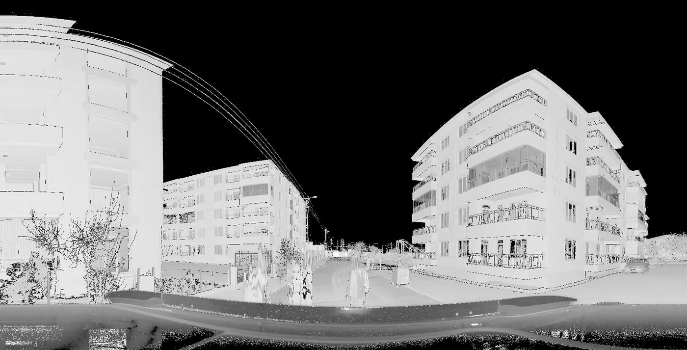
On 6 February 2023 two large earthquakes struck south-eastern Türkiye. In the weeks that followed, reconnaissance teams documented the damage before it was cleared. One of them, a team from the Geotechnical Extreme Events Reconnaissance (GEER) association, spent 27 March to 1 April 2023 in İskenderun (Hatay) and Gölbaşı (Adıyaman). Diane Moug, Jonathan Bray and Patrick Bassal led the work, with Sena Begüm Kendir and Arda Sahin on the team.
They focused on buildings where the ground had liquefied: buildings that had settled, tilted or pushed up the pavement around them. To record that geometry before it changed, they scanned the sites with a terrestrial laser scanner, a FARO Focus3D X 330.
The data is published on DesignSafe-CI as project PRJ-4550, under the Open Data Commons Attribution licence. Anyone can download it, use it and build on it, as long as the source is credited.
What the data set contains
PRJ-4550 holds two data sets, one per town, each with its own DOI. The İskenderun scans cover buildings B, C, E, F and K, and a group of four buildings labelled G, H, I and J, near Atatürk Boulevard. The Gölbaşı scans cover buildings Ag, Bg, Cg and Dg.
The team registered the scans of each site in FARO SCENE 2023.0.1, exported them as one LAS file per site, and converted those to CloudCompare's .bin format for the upload. The project also includes the individual scan folders in FARO's own .fls format, which is what made it useful to us. A short data report describes the folder layout, the building references and the coordinates of each site, and the GEER Phase 3 report puts the observations in their engineering context.
Why raw FARO scans matter to us
Albireo, our .fls reader, has to be tested on real files written by real scanners in the field, not on synthetic data. Real projects are hard to come by: survey firms rarely publish raw scans, and when they do, the files are usually already converted.
The GEER scans gave us exactly what we needed. They come from a widely used terrestrial scanner, were written by FARO's own firmware during a real campaign, and are documented well enough to know what each scan shows.
Six of the sixteen scans in our reference tests come from this project: five from Gölbaşı and one from İskenderun. For each of them we read the .fls file with Albireo and compare every point with an export that SCENE LT wrote from the same file. On these scans 100 % of shared points agree within 2 mm, and the median difference is 0.005 mm, which is the precision limit of the PTX format used for the comparison. The Albireo page has the full table, and it is equally open about what we cannot do yet.
The panorama at the top of this page is one of those scans, read by Albireo: the corner between buildings Ag and Bg in Gölbaşı.
How to cite it
If you use the data, cite the two data sets by their DOIs and credit the licence. The full references are listed below. For the engineering findings, the GEER Phase 3 report and the reconnaissance paper in Earthquake Spectra are the places to start, and a 2026 paper in Acta Geotechnica looks at the role of soil type in the damage in Gölbaşı.
If your scans are stuck in .fls
Field campaigns like this one often end with a folder of .fls files and a SCENE licence tied to one laptop. If you have FARO scans you can no longer open, or want them in an open format, we convert them to E57, LAS or PTX and can recover archived projects. The first conversion is free.
Our thanks go to the GEER team for collecting this data under difficult conditions and for publishing it openly.
Sources
- Moug, D., Bray, J., Bassal, P., Kendir, S. B. and Sahin, A. (2024). Lidar Scans of Geotechnical Earthquake Damage at Building Sites in Gölbaşı, Adıyaman. DesignSafe-CI, PRJ-4550. doi:10.17603/ds2-fcry-0191
- Moug, D., Bray, J., Bassal, P., Sahin, A. and Kendir, S. B. (2024). Lidar Scans of Liquefaction-Impacted Buildings in İskenderun, Hatay. DesignSafe-CI, PRJ-4550. doi:10.17603/ds2-q5x1-e497
- Moug, D. and Bassal, P. (2023). February 6, 2023 Türkiye Earthquakes: GEER Phase 3 Team Report on Selected Geotechnical Engineering Effects. GEER Association Report 082-S1. doi:10.18118/G6F379
- Moss, R. E. S. et al. (2025). Geotechnical and geological reconnaissance observations of the 6 February 2023 Türkiye earthquakes. Earthquake Spectra. doi:10.1177/87552930241281007
- Karray, M. et al. (2026). Role of soil type in geotechnical damage observed in Gölbaşı during the 2023 Türkiye earthquake sequence. Acta Geotechnica. doi:10.1007/s11440-026-03122-2
- Open Data Commons Attribution License (ODC-BY) v1.0. https://opendatacommons.org/licenses/by/1-0/